
قم بتنزيل التطبيق


معلومات عنا
حقوق الطبع والنشر © 2024 Desertcart Holdings Limited
قم بتنزيل التطبيق
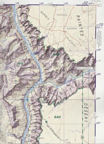
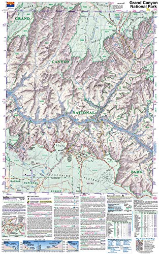
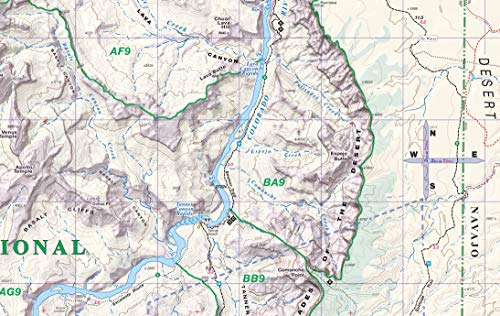


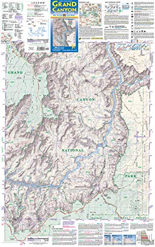
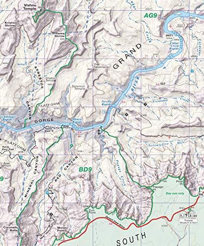


Grand Canyon Trail Map 7th Edition [Sky Terrain, Kent Schulte, Kent Schulte, Kent Schulte] on desertcart.com. *FREE* shipping on qualifying offers. Grand Canyon Trail Map 7th Edition Review: The best - Love this map! Much better than the maps offered in gift shops once inside the park. Review: Get this one. Don't bother with Nat Geog raphic version - This version has so much information packed into a small space, you could plan and hike without anything else. Campgrounds labeled, water sources indicated, distances between points calculated and listed in an easy to read format. On my last hike my friend had the Nat Geo map and I carried this. I could pick out our location just as easily but I also had instant access to additional information. I especially liked the small square on the back to help identify the various rock layers by color. It helped us keep the canyon in perspective vertically and horizontally. Would buy it again.
| Best Sellers Rank | #538,324 in Books ( See Top 100 in Books ) #53 in Grand Canyon Travel Books #618 in West Mountain United States Travel Books #652 in Maps (Books) |
| Customer Reviews | 4.7 4.7 out of 5 stars (270) |
| Edition | 7th |
| ISBN-10 | 0966550846 |
| ISBN-13 | 978-0966550849 |
| Item Weight | 3.2 ounces |
| Language | English |
| Print length | 2 pages |
| Publication date | February 15, 2020 |
| Publisher | Sky Terrain |
S**L
The best
Love this map! Much better than the maps offered in gift shops once inside the park.
S**R
Get this one. Don't bother with Nat Geog raphic version
This version has so much information packed into a small space, you could plan and hike without anything else. Campgrounds labeled, water sources indicated, distances between points calculated and listed in an easy to read format. On my last hike my friend had the Nat Geo map and I carried this. I could pick out our location just as easily but I also had instant access to additional information. I especially liked the small square on the back to help identify the various rock layers by color. It helped us keep the canyon in perspective vertically and horizontally. Would buy it again.
G**L
Beautiful, unmatched - but North Rim beware
There's no map out there like this one. It's outstanding. My issue with it is formatting. It's divided front and back at an inconvenient place - between Shoshone and Grandview Points on Desert View Drive on the South Rim. The division of the North Rim is worse - Cape Royal and Bright Angel Point are on different sides, and Point Imperial doesn't even appear on the map. This shouldn't stop you from getting this map. The way it's colored makes it easier to understand all the geological features you see from the rims. That's mainly what I use it for. If you're going to the North Rim, you'll need the National Geographic Arizona Grand Canyon North and South Rims map, which had Point Imperial and the main North Rim points on the same side of the map. No problem, though. Can you really have enough Grand Canyon maps? :-)
R**D
Only useful for defined trails
For what it is, this map is a good purchase. The map is fine for defined trails. I wouldn't rely on it if your trip requires any route finding. I can't find a UTM grid reader for the 1:40000 scale and 2KM squares and they don't have a 100 meter scale on the map for me to easily make my own corner grid. So you can't get great accuracy with UTM. However, GPS can be spotty in the Big Ditch so you shouldn't be reliant on it anyhow. If you need a map for general planning and getting general direction, this is the one to get. If you need detail for route finding, you still need a USGS quad (if you need this, you probably don't need me telling you this). If you're only doing an overnight hike on the Corridor trails, you don't need to buy this. The map they give you with the permit is sufficient. Even though it is good for what it is, I docked it a star because they didn't put a 100 meter scale on it. This would have been an easy add with a lot of value.
B**J
Great.
Really helping me on 5 day backpack.
M**S
Best map for Backpackers
This is definitely the best map for backpacking. That being said, it is only as good as the information provided to the map makers. It rates the trail or trail section by difficulty which is extremely useful in trip planning. The water sources are listed on each trail. This is incredibly useful. The contour lines are easy to find and count. The important features are labeled. The map is very durable. It's water resistant and tear resistant. It's not idiot proof. When they build a better map, someone builds a better idiot.
A**L
An AZ Hiker's Favorite Map for Grand Canyon
It's all been said by other reviewers. I'll simply add that I find this map FAR and AWAY easier to read than the Trails Illustrated maps. If your eyes, like mine, are over 50 years old, you may, too. It covers the core of Grand Canyon National Park, at a great scale. Just be sure you review the information about what this map covers, if you're thinking about hiking in an extremely remote part of the Canyon (particularly in parts more than a few miles west of Hermit's Rest). The images provided by Amazon at the top include an image that shows the area covered by this map, compared to the 7.5 minute quads. In addition to the map, this document provides brief descriptions of all the trails (both maintained and unmaintained) so you could use this and not need a separate guidebook.
S**L
I really like these maps
I really like these maps. This covers the majority of the Grand Canyon trail system and this is the map that the park ranger told me he prefers to see visitors have on hand. Very durable. Most importantly, very accurate. I used Sky Terrain maps last summer in the Aspen/Crested Butte area and was highly impressed. My experience with the GC map did nothing but reinforce that opinion. I think they set the standard in topographic maps. If you plan on doing any backpacking in the GC, this is the one to buy. The maps they give you at the park entrance only cover the amenities and roads at the rim and maps of the park shuttle. This has all the backcountry zones and sites, as well as the more established sites well marked. Great for trip planning too. One side covers the rim/slightly western side of the park while the other side covers the eastern aspects of the park. I purchased it for its full coverage of the Escalante and Tonto trail.
ترست بايلوت
منذ أسبوعين
منذ أسبوعين