معلومات عنا
دعم العملاء
احصل على التطبيق

قم بتوجيه الكاميرا لتنزيل التطبيق
حقوق الطبع والنشر © 2024 Desertcart Holdings Limited

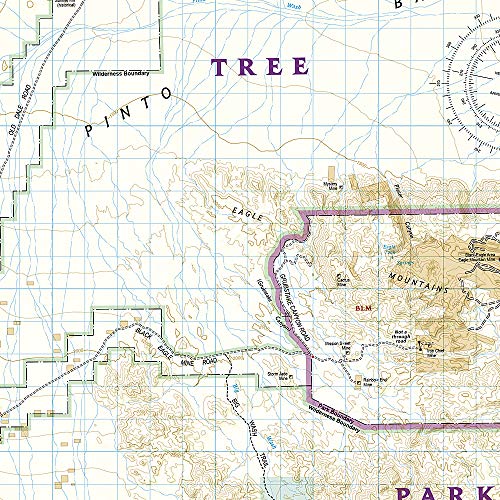
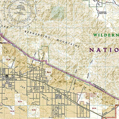
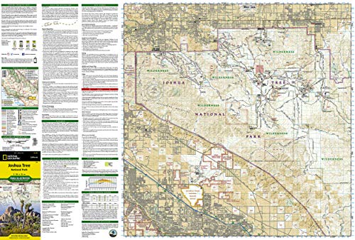
Joshua Tree National Park (National Geographic Trails Illustrated Map) (National Geographic Trails Illustrated Map, 226)
D**N
Quality map
I've never been disappointed with these maps. Quality paper and lots of detail.
B**Y
Good, could be better
This is pretty much the only topo map widely available for Joshua Tree NP, and is good enough for a successful trip.The good: It has a lot of trails and landmarks, including some that are not on the National Park Service brochures, and I made good use of this. The material is durable and waterproof (you might not think you need the latter feature in the desert, but I got rained on for most of a day on my trip).The not-so-good: The countour interval is probably a little too big. Oftentimes you can find yourself walking in a canyon from which you cannot see out, but on the map it appears as flat ground. This is especially problematic on some of the trails not mentioned or maintained by NPS; the map also doesn't make a distinction between these trails and the official ones, so you may find yourself somewhere that NPS doesn't really support.I'm also used to some of the other NatGeo maps that have more trail/hike summaries and info about the park's landmarks; this map has a little safety/planning info, but nothing really useful for determining what to see. One entire side of the map is dedicated to the Eastern half of the park, which doesn't really have much of interest to the average person, so this may have been a good spot to add some insets or trail notes.Overall, I'd definitely recommend it, but you may want to couple it with a guidebook or recommendations from a ranger so you know how to get the most of your trip.
R**T
Good basic map of Joshua Tree NP
It is impossible to get a comprehensive trail map of Joshua Tree National Park, but this Nat Geo version is the best one I have found. It's a good basic map that gives an overview of the entire park and some of the trails, and I appreciate that it is topographic in nature. It is also waterproof and tear-resistant .... a definite plus if you want to take it hiking with you.
A**R
Helpful full color map.
Nice full color map. It is complete with points of interest and popular trails. Very helpful with maximizing time in and around Joshua Tree National Park.
J**O
Map it!
Nat geo maps are always good!If your backpacking, or other outdoor activity, they are highly recommended.
M**C
Good All Purpose Map
Just having returned from Joshua Tree National Park, I found this map a generally good all purpose map for roads and major points of interest. Clearly better than a schematic map online (while the park may say they have some maps or brochures, none were available at the trail heads). This map does not have all of the turnouts or points of interest. You can't use this for navigating with map and compass in the back country; the scale is too big. Do you absolutely have to have this map to visit the park? No. Is it really helpful? Yes.
R**A
Great map. Of course
Great map. Of course, from Nat Geo - we expect good qual.Downside: the area (JT NP) is actually relatively easy to map. Thus, the free map from NP (received at entry) is about as good as this.The Nat Geo map should justify its cost with a lot more value-added. e.g. sub-area maps (for specific trails), or more info on sketchy trails, or more geological info, or more terrain info. Should be do-able. Moral to the story: Nat Geo: don't just use your template for all areas; instead, apply local intelligence to a particular localization.
M**.
Very detailed
Very detailed map. Much more detailed than what you can pick up at the park. Water resistant is a bonus and will use again
A**R
Great quality & easy to use
We’ve visited Joshua Tree National Oark a few times before but decided to buy a map so we could explore off road a little. Great map for this
M**.
Five Stars
Excellent map
P**X
Très bonne carte
mais celle distribuée à l'entrée du parc peut suffire. Peu de risques que la carte NG, fort solide et résistante aux intempéries, soit mouillée lors de votre visite!
ترست بايلوت
منذ شهر
منذ أسبوعين