تسليم إلى EGYPT
للحصول على أفضل تجربة احصل على التطبيق
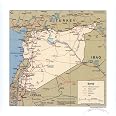
Gifts Delight Laminated 24x24 Poster: Large Detailed Political map of Syria with Roads, Railroads and Cities - 2007 Syria Asia
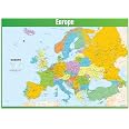
Europe Map Classroom Poster - EXTRA LARGE 33” x 23.5” - Laminated - Map of Europe Geography Class Decoration - Wall Chart by Daydream Education
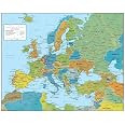
Europe Wall Map GeoPolitical Edition by Swiftmaps (18x22 Laminated)
Large detailed political map of Syria with roads, railroads and cities - 2007 Syria Asia Poster Tags: Large detailed political map of Syria with roads railroads and cities - 2007 Syria Asia
ترست بايلوت
زينب ن.
منذ أسبوع
أنجالي ك.
منذ شهر
الرسوم والضرائب مشمولة
30 يومًالمستخدمي عضوية PRO
15 يومًابدون عضوية
فيكرام د.
منذ أسبوعين