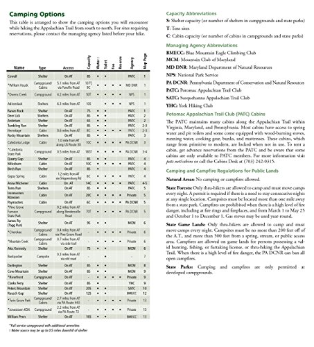
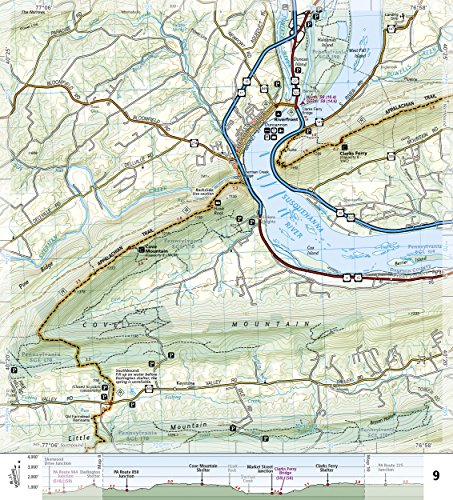
Description
- Printed on waterproof tear-resistant paper. Full UTM grid to aid with GPS navigation. 4 1/4 in. x 9 3/8 in. folded.
- Scale 1:63,350. Includes detailed topographic maps at a detail of 1 in. = 1 mile. Each page is centered on the Appalachian Trail and overlaps adjacent pages.
- Trail profile shows distance between shelters, camping areas, and trail access points. Step by step visual guide. Clearly marked trails for hiking, biking, horseback riding, ATV, and more.
- Color-coded boundaries of state parks, national recreation areas, wilderness areas, marine sanctuaries, and wildlife refuges. Hundreds of points of interest, including: scenic viewpoints, campgrounds, boat launches, swimming areas, fishing access points, and more.. Detailed road network.
- © 2014
Appalachian Trail: Raven Rock to Swatara Gap Map [Pennsylvania] (National Geographic Topographic Map Guide, 1506)

![Appalachian Trail: Raven Rock to Swatara Gap Map [Pennsylvania] (National Geographic Topographic Map Guide, 1506)](https://images-na.ssl-images-amazon.com/images/I/511ZTCN458L.jpg)